বাবলা কাঠি babla kathi
Wednesday, 4 May 2022
Saturday, 23 May 2020
Methods of Linear Measurements
Approximates Methods of Linear Measurements
These methods are used in reconnaissance survey or to detect major mistakes committed while measuring with better methods. On smooth roads they can give results within 1 % error. These approximate measurements may be by the followings -
(i) pacing
(ii) using passometer
(iii) using pedometer
(iv) using odometer
(v) using speedometer.

(i) Pacing: In this method surveyor walks along the line to be measured and counts the number of steps. Then the distance measured is equal to number of steps × average length of a step.
Average length of a step can be found by walking along a known length. A normal man takes a step of length 0.75 m to 0.8 m.
(ii) Using Passometer: A passometer is a watch-like instrument which is carried vertically in the pocket of shirt or tied to a leg. It records number of steps taken. Thus the problem of counting number of steps is eliminated in this approximate method of linear measurement.
(iii) Using Pedometer: This instrument is similar to passometer but it can record the distance instead of number of steps. In this, zero setting and setting of step length is made before walking.
(iv) Odometer: This instrument is attached to the wheel of a cycle or other vehicle. It records the number of revolutions made by the wheel. Knowing the circumference of the wheel, the distance traveled may be found.
(v) Speedometer: Odometer calibrated to give distance directly is called speedometer. This is to be used for particular vehicle only. All automobiles are provided with speedometers. By running the vehicle along the line to be measured distance can be found.
Monday, 18 May 2020
GEODETIC SURVEYING
Geodetic survey is actually a vast area survey process. The line joining any two points is considered as a curved line. The triangle formed by any three points is considered to be spherical and the angle of the triangle is assumed to be spherical angles. Geodetic survey is conducted by the Survey Of India department, and is carried out over an large area exceeding 250 KM2.

The first geodetic survey of note was observed in France during the latter part of the 17th and early 18th centuries and immediately created a major controversy. JEAN PICARD began an arc of triangulation near Paris in 1669-70 and continued the work southward until his death about 1683. His work was resumed by the Cassini family in 1700 and completed to the Pyrenees on the Spanish border prior to 1718 when the northern extension to Dunkirk on the English Channel was undertaken.
The survey created a major controversy. For the results indicated that the earth was a prolate ellipsoid, which contradicted Issac Newton's 1687 postulate that it was an oblate figure. To resolve the hue and cry that followed, the French Academy of Sciences in Paris proposed in 1733 that the length of the meridian be measured near the equator and compared with that obtained in France. Later it was decided to do the same in the Arctic region. The Torne River valley north of Tornio in Lapland on the Swedish-Finnish border was chosen as the northern site and observations were begun in 1736 and completed two years later.
The results showed conclusively that one degree of the meridian was longer in Lapland than at Paris and proved Newton's postulate to be correct. The expedition to Peru, the present day Ecuador departed in 1735 and returned nine years later with results that confirmed the Lapland finding, i.e. one degree of the meridian is shorter at the equator than in France.
PLANE SURVEYING
We know that the shape of the earth is spheroidal Thus, the surface is obviously curved . But in plane surveying, the curvature of the earth is not taken into consideration. This is because Plane Surveying is carried out over a small area. So the surface of the earth is considered as plane. Basically a triangle is formed by assuming three points and the angles are assumed to be plane angles.

NOTE : The difference between the earth and the subtended chord on the surface of the earth is only 0.1 M in 18.2 KM, 0.3 M in 54.3 KM. respectively.
SURVEYING
Surveying is the art of determining the relative position of different objects on the surface of the earth by measuring the horizontal distances between them and by preparing a map to any suitable scale . Thus , in this discipline , the measurements are taken only in the horizontal plane .
The aim of surveying is to prepare a map to show the relative position of the objects on the surface of the earth . The map is drawn to some suitable scale . It shows the natural features of a country . Such as roads, villages, railways, rivers, etc. Maps are also include details of different engineering works .
Uses of Surveying :
- For preparing the contour map to determine the best possible route and amount of earthwork required.

contour map - For preparing the engineering map showing engineering details like highways, railways, canals, dams, reservoirs, etc.

engineering map - Maps prepared for marking boundaries of countries, states, districts etc., avoid disputes.

boundaries of countries - For preparing the topographical map which shows hills, rivers, forests, valleys, etc.

topographical map - For planning and estimating project works like roads, bridges, railways, airports, water supply and waste water disposal surveying is required.
- Marine and hydro-graphic survey helps in planning navigation routes and harbours.

world route map - For preparing a military map showing different strategic points important for the defence of a country.

military map - Mine surveys are required for exploring mineral wealth.
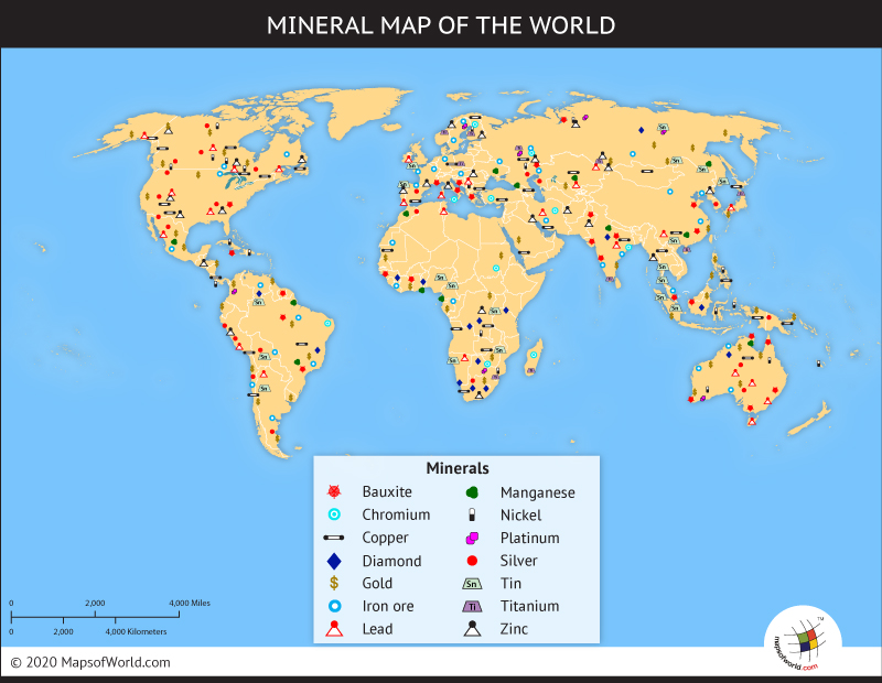
world mineral map - For preparing archaeological map showing the places where ancient relics may have lied.

archaeological map - Astronomical survey helps in the study of movements of planets and for calculating local and standard times.

Movement of planets
Subscribe to:
Comments (Atom)